Introduction
The Straits of Malacca and Singapore (Straits) is one of the most important strategic maritime passages of the world. The Straits form the shortest sea-link between the Indian and Pacific Oceans. The importance of the Straits as an international waterway has been well-established. It represents the longest strait in the world used for international navigation and supports the bulk of the maritime trade between Europe and Pacific Asia.
It is estimated that more than one third of world trade and half its oil is transported through the Straits. The rapid economic development in Asia and port developments along the Straits will further enhance the importance of the Straits. As a result, the number of ships and the tonnage of goods passing through the Straits will increase. Currently, the Straits of Malacca and Singapore bear more than 100,000 vessel movements per year. Beside the increasing traffic movements in the Straits, it is also observed that vessels transiting the Straits are becoming larger and faster. Navigating through these Straits is increasingly challenging especially at port approaches and narrow traffic lanes.
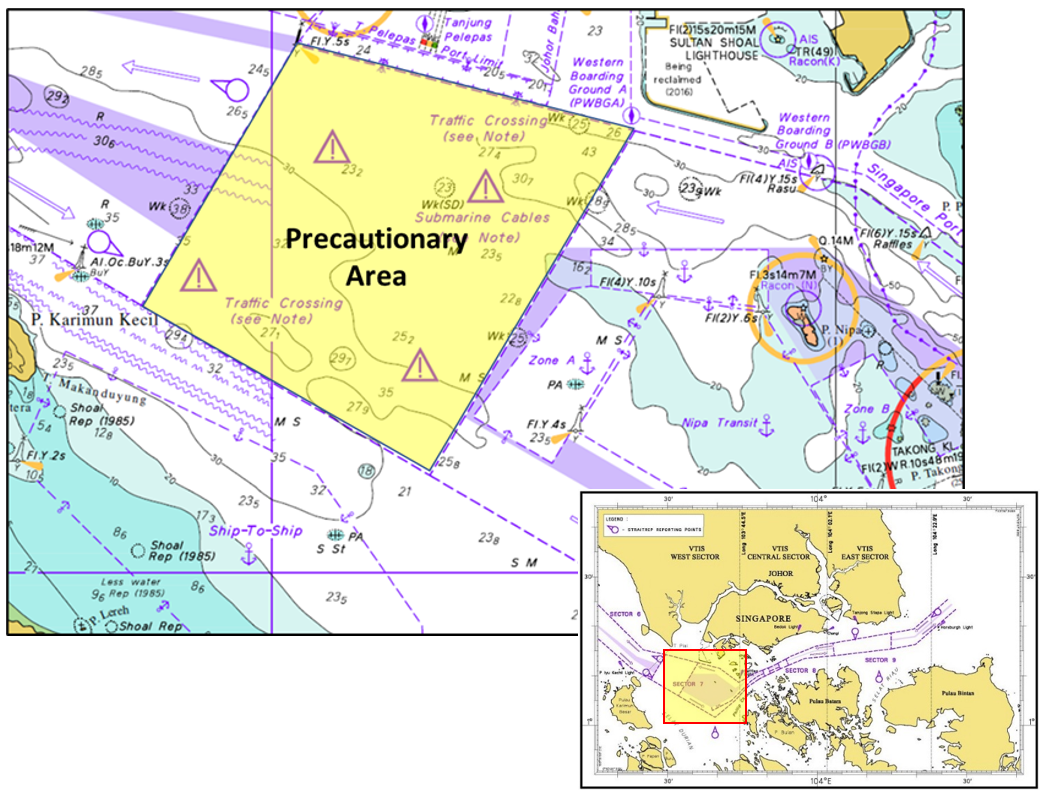
The Traffic Separation Scheme (TSS), for safer navigation in the Straits, was brought into force on 1 May 1981. In 1998, the IMO adopted the Mandatory Ship Reporting System in the Straits of Malacca and Singapore, known as “STRAITREP”, as proposed by Indonesia, Malaysia and Singapore. It aims to enhance the safety of navigation, protect the marine environment, facilitate the movement of vessels, search and rescue (SAR) and oil pollution response operations. The entire TSS is divided into 9 sectors with Sectors 1 to 6 lying in the Malacca Strait and Sectors 7 to 9 in the Singapore Strait. Klang VTS and Johor VTS are the authorities for Sectors 1 to 5 and Sector 6 respectively while Singapore Vessel Traffic Service (VTS) is the authority for STRAITREP in Sectors 7 to 9.
Singapore Vessel Traffic Service has observed a marked increase in shipping movements in the STRAITREP Sector 7. This is due to the growth in port activities in both Port of Tanjung Pelepas in Malaysia and Tuas Port which lies at the West of Singapore. The plan to expand the ports and marine activities in the area are underway. It is anticipated that these developments will impact the shipping traffic in the Precautionary Area in Sector 7. Vessels arriving and departing ports, anchorages and transiting the area will face challenging crossing situations as the shipping traffic will increase in the near future.
We are seeking feedback from the shipping community in order to enhance safety of navigation in the Precautionary Area in STRAITREP Sector 7. In particular, we are looking for feedback from navigating officers with actual and recent experience of navigating the Straits of Malacca and Singapore. It will take approximately 10 minutes to complete the questionnaire.